



Table of Contents
In the southeastern corner of Iran, where the Iranian plateau meets the edge of the Dasht-e Lut — one of the hottest and most inhospitable deserts on earth — there is an oasis. And rising from that oasis, built entirely from the mud beneath it, is a city.
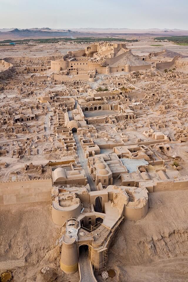
Arg-e Bam is the world’s largest adobe structure, a vast fortified complex spanning approximately 18 hectares and rising up to 20 meters in height. Its towers and battlements, its mosques and markets, its governor’s residence and soldiers’ quarters — all of it formed from sun-dried mud brick and layered clay, shaped by hand, and sustained for more than two millennia by a system of underground water channels that turned desert into garden.
The origins of Bam can be traced back to the Achaemenid period, the 6th to 4th centuries BC. Its heyday was from the 7th to 11th centuries, being at the crossroads of important trade routes and known for the production of silk and cotton garments.
On the morning of 26 December 2003, at 5:28 AM, an earthquake measuring 6.5 on the Richter scale struck almost directly beneath the city. The quake caused catastrophic destruction, leading to the loss of 26,271 lives and injuring over 30,000 people. Approximately 85 percent of the buildings in Bam, including historical structures made from adobe, collapsed. The citadel — which had withstood invasions, sieges, and centuries of desert wind — was reduced to rubble in a matter of seconds.
Seven months later, UNESCO inscribed Bam and its Cultural Landscape on the World Heritage List. The inscription was simultaneously an act of recognition and an act of commitment: a declaration that what had been built here, over 2,500 years, was worth the world’s sustained attention and support to rebuild.
This is the story of that place — its origins, its architecture, its water, its trade, and its recovery.
Before the Citadel: The Oasis
To understand Bam, you first need to understand the problem it solved.
The region of Kerman in southeastern Iran receives almost no rainfall. The Dasht-e Lut to the east is one of the most extreme desert environments on the planet — surface temperatures there reach some of the highest ever recorded anywhere on earth. Nothing about this landscape suggests a settlement of any scale, let alone a city that would grow to become a significant node on the Silk Road and a producer of fine cotton and silk garments traded across the ancient world.
The solution was water engineering. The creation and growth of the city was based on the underground irrigation canals, the qanāts, of which Bam has preserved some of the earliest evidence in Iran. The archaeological discoveries of ancient qanāts in the south-eastern suburbs of Bam are datable to the beginning of the 2nd century BC.
A qanat is a gently sloping underground channel, dug by hand, that taps into groundwater sources in the foothills and carries them by gravity across distances of many kilometers to the surface at lower elevations. The system requires no pumps and no external power — only the slope of the land and the ingenuity of the people who designed and maintained it. In Bam, these channels fed a network of gardens and date palm orchards that made the oasis not merely habitable but genuinely fertile. The palm groves of Bam — still among the most productive in Iran — are the direct descendants of plantations first established by the people who dug those early qanāts.
The series of qanāt in this area is datable at least to the Parthian period if not Achaemenid. Recent archaeological explorations have revealed remains of two ancient villages or towns to the east of the Arg, including the remains of a fire temple and remains of ancient qanāts. The Zoroastrian fire temple is a reminder that the sacred dimension of this oasis predates Islam by many centuries — that people came here, built here, and considered this water-in-the-desert worthy of religious as well as practical significance.
Arg-e Bam: 2,500 Years of History
Achaemenid and Parthian Foundations
The origins of Arg-e Bam date back more than 2,000 years. While the surviving structures belong mostly to later periods, archaeologists believe the site may have been occupied as early as the Achaemenid Empire (6th–4th century BC). The earliest surviving phases of the citadel are generally attributed to the late Parthian and early Sassanian periods, when a small fortress developed into a fortified settlement that became the heart of Bam for centuries to come.
The Sassanian Era (224–651 AD)
During the Sassanian Empire, Arg-e Bam was strengthened with new walls and defensive structures, becoming an important military and administrative center. Some historians also associate the fortress with Kajarān, a stronghold mentioned in Ferdowsi’s Shahnameh, although this identification remains debated.
The Islamic Golden Age (7th–11th Centuries)
After the Islamic conquest of Persia, Bam flourished as a major oasis city and trading center. Medieval writers described it as a prosperous settlement known for its qanat irrigation system, fertile gardens, and fine cotton textiles. Thanks to its strategic location along the Silk Roads, Bam connected Persia with Central Asia, the Indian subcontinent, and the Persian Gulf, making it an important hub for trade and cultural exchange. This rich history is one of the reasons Arg-e Bam was later inscribed as a UNESCO World Heritage Site in Iran.
The Seljuk Period (11th–13th Centuries)
Arg-e Bam continued to grow during the Seljuk era. Several buildings within the citadel, including its iwan-style mosque, are generally attributed to this period, reflecting the architectural styles that spread across Iran at the time.
Decline and Abandonment
Arg-e Bam began to decline during the 18th century as regional conflicts and changing trade routes reduced the city’s commercial importance. The Afghan invasion of 1722 and later military struggles further weakened the settlement. By the early 20th century, the citadel had been converted into a military garrison, serving this role until 1932, after which it was abandoned as residents gradually moved to the modern town outside the fortress walls.
Conservation efforts began in the 1950s and expanded significantly from the 1970s onward. Before the devastating 2003 earthquake, Arg-e Bam had become one of Iran’s most important historical attractions, welcoming hundreds of thousands of visitors each year and standing as a symbol of the region’s rich cultural heritage.

📷Photo by Diego Delso on Wikicommons
Adobe Architecture: Building from the Desert
There is a philosophical dimension to the architecture of Arg-e Bam that becomes clear the longer you spend inside it. Every material used to build this city came from within a few kilometers of where it stands. The mud of its walls is the same mud as the valley floor. The palm wood of its ceiling beams grew in the orchards the qanāts fed. The city was not built in the desert — it was built from the desert, and its architecture reflects a millennia-long conversation between human ambition and the materials the landscape provided.
Arg-e Bam is the most representative example of a fortified medieval town built in vernacular technique using mud layers (Chineh). The two primary techniques were Chineh — layers of puddled mud applied wet and allowed to dry in successive courses — and Khesht — sun-dried mud bricks formed in wooden molds and laid in courses with mud mortar. Both were in use at Bam across its entire building history, sometimes in the same wall, their different textures and structural properties complementing each other in ways that experienced builders understood intuitively.
The Citadel’s Four Zones of military, civic, and domestic space
The Outer Defensive Wall runs the perimeter of the entire complex, punctuated by 38 watchtowers and surrounded, on the most vulnerable sides, by a dry moat. The wall’s thickness and the arrangement of its towers reflect sophisticated thinking about defensive geometry: the spacing of towers was calculated so that archers could cover every section of the wall between them.
The Lower City (Shahrestān) occupied the majority of the citadel’s interior — a dense urban fabric of residential quarters, markets, workshops, and the Jame Mosque. The bazaar was located here, its covered corridors providing the shade essential to commerce in this climate. The residential districts were organiظed around courtyard houses whose high walls created cool, private interior spaces protected from both the sun and the desert wind.
The Garrison and Stables occupied the middle section of the complex — barracks for soldiers, stables for horses, storage facilities for provisions. The scale of these facilities reflects the strategic importance of the citadel as a military post for whichever power controlled the Kerman region.
The Governor’s Residence stands at the summit of the complex, on the highest point of the natural hill — protected by a double fortification wall and commanding views across the entire oasis and far into the surrounding desert. From this vantage point, the relationship between the city and its landscape becomes fully legible: the palm groves stretching south, the qanat channels threading through the gardens below, and beyond them, the empty desert in every direction.
The Yakhchal: Ice in the Desert of the citadel walls stands a structure that many visitors overlook and few articles about Bam adequately explain: a large Yakhchal, or ice house.
In a city where summer temperatures regularly exceed 40°C, ice was not a luxury but a practical resource — used for food preservation, for cooling drinking water, and for medical purposes. The Yakhchal was a conical mud-brick dome, sometimes over fifteen meters high, designed around a principle of passive refrigeration: the dome’s shape, combined with a shaded pool and a system of qanat-fed cold water channels, allowed ice to be produced in winter and stored through the summer months. The thick mud-brick walls provided insulation; the dome’s orientation minimized direct sun exposure; and the geometry of the structure created air circulation patterns that maintained the interior temperature below freezing well into the heat of summer.
The Yakhchal at Bam is one of the finest surviving examples of this technology in Iran — a reminder that the ingenuity displayed in the qanat system extended across every aspect of the settlement’s relationship with its challenging environment.

📷Photo by Laleh M on Wikicommons
The Qanat: Engineering Life from Desert
UNESCO’s inscription of Bam was not simply about the citadel. It was about the relationship between the citadel and the landscape that made it possible — and at the center of that relationship is the qanat.
The inscribed property contains historical evidence of the evolution of qanat construction from the first millennium till the present. This is a remarkable claim: that a single site holds within it the full developmental history of one of the ancient world’s most important technologies, from its earliest known examples to qanats that are still flowing today.
A qanat begins with a mother well, sunk into the groundwater-bearing layers at the base of a mountain or elevated plain. From this source, a gently sloping tunnel is dug by hand, progressing downhill toward the settlement it will serve. Access shafts are sunk at regular intervals — typically 20 to 50 meters apart — both to remove spoil during construction and to allow maintenance. At the surface, these shafts appear as a line of circular mounds stretching across the landscape, following the invisible channel below — one of the most distinctive visual signatures of the Iranian plateau when seen from above.
The social system that maintained the qanāts was as sophisticated as the engineering. Rights to qanat water were carefully allocated, documented, and adjudicated. Communities of specialists — the muqannis — dedicated their lives to the construction and maintenance of the tunnels, passing their skills from father to son across generations. This social infrastructure was as essential to the survival of Bam as the physical channels themselves.
The system is based on a strict social system with precise tasks and responsibilities, which have been maintained in use until the present, but has now become vulnerable to irreversible change. The threat is not geological but cultural: as younger generations leave agricultural and craft traditions for urban employment, the pool of people with the knowledge and willingness to maintain the qanats is shrinking. UNESCO recognized this vulnerability explicitly in its inscription — the danger is not that the channels will collapse but that the knowledge required to maintain them may be lost.
UNESCO Status: The 2004 Inscription
Bam and its Cultural Landscape was originally inscribed on both the World Heritage List and the List of World Heritage in Danger in 2004 due to damage it sustained from an earthquake in December 2003. The dual inscription — World Heritage and in Danger simultaneously — was unprecedented. It reflected both the outstanding universal value of what had existed and the urgency of the international commitment required to save what remained.
UNESCO inscribed Bam under four specific criteria:
Criterion (ii): Bam developed at the crossroads of important trade routes and became an outstanding example of the interaction of various cultural influences — Persian, Arab, Central Asian, and Indian — across more than a millennium of Silk Road commerce.
Criterion (iii): The cultural landscape bears exceptional testimony to the development of a trading settlement in a desert environment, and to the social and engineering systems — particularly the qanats — that made it possible.
Criterion (iv): Arg-e Bam is the most representative example of a fortified medieval town built in vernacular earthen architecture — the most complete surviving example of the Chineh and Khesht building tradition at a monumental scale.
Criterion (v): The cultural landscape of Bam is an outstanding example of traditional human settlement and land use in a desert environment, representing a civilisation’s long interaction with its natural landscape through water management, agriculture, and fortified urbanism.
The “in danger” designation brought immediate international support. Reconstruction experts rushed to rebuild Bam. A decade later the city had come back to life and UNESCO removed the citadel from its danger list. Experts from Japan, Italy, France, and dozens of other countries participated in stabilization and conservation work alongside Iranian specialists. The total reconstruction investment exceeded $667 million. The citadel was formally removed from the List of World Heritage in Danger after sustained progress on conservation and urban management — a recognition that, while the work of restoration continues, the site’s outstanding universal value is no longer at imminent risk.
26 December 2003: The Earthquake
At 5:28 in the morning of the day after Christmas, while most of Bam’s residents were still asleep, the fault line that runs beneath the city moved. The quake caused catastrophic destruction, leading to the loss of 26,271 lives and injuring over 30,000 people. Approximately 85 percent of the buildings in Bam, including historical structures made from adobe, collapsed.
The particular cruelty of an earthquake at that hour, in that material, was total. Mud-brick construction performs well under many conditions — it insulates against heat, resists wind, and breathes with the desert climate in ways that modern concrete cannot. But under seismic loading, the heavy, unreinforced walls collapse suddenly and completely.
The destruction of Bam signified more than physical loss — it was a blow to Iranian cultural identity and global heritage. UNESCO and cultural historians emphasized the irreplaceable nature of the citadel’s architecture. The walls that had withstood Mongol incursions and centuries of desert wind were, in a few seconds of geological violence, reduced to mounds of dried mud. The governor’s residence on the hill — the structure that had commanded the oasis for two thousand years — collapsed into itself.
Reconstruction posed immense challenges. Balancing heritage preservation with modern safety standards stirred debate among architects, historians, and urban planners. Some argued for rebuilding the citadel using traditional techniques to maintain authenticity; others pushed for contemporary materials to ensure earthquake resistance. The debate was not merely technical — it was a question about what restoration means and what it is for. A citadel rebuilt in reinforced concrete would be structurally safer but would no longer be the thing it was. A citadel rebuilt in mud brick using traditional techniques would be authentic but potentially vulnerable to the next seismic event.
The solution adopted was neither pure reconstruction nor pure preservation, but a careful, evidence-based conservation process guided by international heritage standards: stabilize what survived, document what was lost, and restore selected elements using traditional techniques where structural and documentary evidence was sufficient to do so reliably. The process is ongoing. Significant sections of the citadel remain under conservation. But the essential structure is stable, and the site is open to visitors.
📷Photo by Morteza Salehi70 on Wikicommons
What to See at Bam
Arg-e Bam — the Citadel and the dominant experience of any visit. Enter through the main gate and proceed into the lower city — the bazaar section, the residential quarters, the Tekiyeh (a central assembly hall), and the Jame Mosque are all accessible and partially restored. The stables and garrison buildings to the middle section of the complex give a sense of the military infrastructure that sustained the citadel across its different political eras.
The climb to the Governor’s Residence at the summit is steep but essential. The view from the upper fortifications — across the palm groves, over the reconstructed sections of the lower city, and out toward the absolute emptiness of the desert — is the best explanation of why this particular hill, in this particular oasis, was chosen as a place to build and rebuild across 2,500 years.
Allow time simply to walk the perimeter of the inner walls and observe the different layers of construction — the Chineh mud courses, the Khesht brick sections, the Seljuk-era mosque porch, the Qajar-era repairs. Like the Jameh Mosque of Isfahan, Arg-e Bam is an architectural timeline, legible in its materials to anyone who looks carefully enough.
Qal’eh Dokhtar — the Maiden’s Fortress
Outside the core area of Arg-e Bam, there is Qal’eh Dokhtar, the Maiden’s Fortress, dating to approximately the 7th century. Situated on a separate hill approximately two kilometers from the main citadel, it predates the principal Arg by several centuries and offers a different perspective on the defensive logic of this landscape — the way natural topography was read and used by early builders to control the approaches to the valley.
The Emamzadeh Mausoleums
The specified remains of protected historic structures include Emamzadeh Zeyd Mausoleum (11th–12th century) and Emamzadeh Asiri Mausoleum (12th century). These mausoleums — shrines to local saints venerated by the Shia community — are among the oldest Islamic structures in the Bam region and demonstrate the continuity of sacred geography in this landscape from Zoroastrian fire temple to Islamic mausoleum across many centuries.
The Palm Groves and Active Qanats
Do not leave Bam without spending time in the date palm groves to the south of the citadel. The palms themselves are a living expression of the qanat system — without the underground channels, none of them could exist. Walking among them at the right hour, when the light is angled and the heat has eased, offers a different register of experience from the citadel: quieter, more agricultural, more immediately connected to the daily human life that the qanats made possible for two thousand years.
Some qanat access shafts are visible from the surface — the characteristic earth mounds running in lines across the landscape. Local guides can point out active channels and explain the maintenance practices that keep them flowing.
Bam Citadel: Visitor Guide
Location: Bam, Kerman Province, southeastern Iran. Approximately 200 km southeast of Kerman city — accessible by road (3–3.5 hours from Kerman).
Opening hours: Generally open daily from 9 AM to sunset. Check locally for current hours, as sections under active conservation may have restricted access.
Time required: The citadel alone requires a minimum of 2 hours for a meaningful visit. A full exploration of the citadel, the surrounding cultural landscape, the Qal’eh Dokhtar, and the palm groves warrants a full day. Overnight in Bam is worth considering for those making the journey from Kerman or further afield.
Best time to visit: October through March, when temperatures are comfortable. Summer visits (June–August) require early morning arrival and significant sun protection — temperatures regularly exceed 40°C.
Combining with other sites: Bam pairs naturally with a visit to the Persian Qanats, separately inscribed as a UNESCO World Heritage Site — two qanat systems near Bam (Qanat Akbarabad and Qanat Qasemabad) are accessible approximately 7 kilometers from the citadel and offer the chance to understand the engineering that sustained the oasis at a more intimate scale.
Final Thought: Arg-e Bam, a Lesson in Endurance
Bam does not earn its significance through grandeur. It earns it through honesty — a city built from the desert itself, sustained by water drawn through hand-dug tunnels, and rebuilt twice over by people who considered this place worth the effort.
The earthquake of 2003 interrupted a 2,500-year conversation between human intelligence and a difficult landscape. What followed — 60 countries responding, UNESCO acting within seven months, a city and its orchards rebuilt alongside its citadel — is the other half of that story. Both halves are visible when you visit.
Bam is not a comfortable site in the way Isfahan is comfortable. But it offers something rarer: an unfiltered encounter with what Persian civilisation was made of, long before the domes and the tilework.
Ready to experience Bam and Iran’s ancient south for yourself?
FAQs about Bam and its Cultural Landscape
1. What is Bam and its Cultural Landscape?
Bam and its Cultural Landscape is a UNESCO World Heritage Site in Kerman Province, southeastern Iran, inscribed in 2004. It encompasses the Arg-e Bam (Bam Citadel) — the world’s largest adobe structure — and the surrounding cultural landscape, including ancient qanat irrigation systems, date palm gardens, and historic structures spanning from the Achaemenid period (6th–4th centuries BC) to the 20th century.
2. Why is Bam a UNESCO World Heritage Site?
Bam was inscribed under four UNESCO criteria: as an outstanding example of the interchange of human values and influences on the Silk Road; as an exceptional testimony to the development of a trading settlement in a desert environment; as the most representative example of medieval fortified earthen architecture; and as an outstanding example of traditional human interaction with a desert landscape through the qanat water management system.
3. What is the Arg-e Bam?
Arg-e Bam — the Bam Citadel — is the world’s largest adobe (mud-brick) structure, a fortified urban complex covering approximately 18 hectares on a natural hilltop in the city of Bam. It contains the remains of residential quarters, a bazaar, mosques, stables, a garrison, and the governor’s residence, all built using the traditional Chineh and Khesht earthen construction techniques. Its origins date to at least the Achaemenid period and it was continuously inhabited until the early 20th century.
4. What happened to Bam in 2003?
On 26 December 2003, an earthquake measuring 6.5 on the Richter scale struck almost directly beneath Bam, killing 26,271 people and injuring over 30,000. Approximately 85 percent of the city’s buildings collapsed, including most of the Arg-e Bam. UNESCO inscribed the site on the World Heritage List in July 2004, simultaneously designating it “in danger” to mobilize international support for its restoration. The site was removed from the danger list after sustained progress in conservation and urban recovery.
5. What is a qanat and why is it important at Bam?
A qanat is a hand-dug underground irrigation channel that carries water by gravity from groundwater sources in elevated terrain to settlements at lower elevations. At Bam, qanats dating back at least to the 2nd century BC made it possible to create and sustain an oasis in one of Iran’s most extreme desert environments. The Bam cultural landscape preserves some of the earliest known evidence of qanat construction in Iran, and several qanat systems in the region remain in active use today.
6. Is Bam worth visiting despite the earthquake damage?
Yes — and the earthquake is part of what makes the site significant to visit today. Sections of the citadel have been carefully restored and are fully accessible. The scale of the complex, the quality of the earthen architecture, the surrounding palm groves, and the landscape’s connection to the qanat system together make Bam one of the most distinctive and atmospheric heritage sites in Iran. The ongoing restoration work is itself an education in the challenges and methods of earthen conservation.
7. How do I get to Bam from Tehran?
The most practical route for international visitors is a domestic flight from Tehran to Kerman Airport, approximately 1.5 hours, and then take a driver, taxi or bus to Bam. Alternatively, take the overnight train from Tehran to Kerman and travel the final 200 km to Bam by road. Bam can also be incorporated into a road journey through southeastern Iran connecting Kerman, Bam, and the Dasht-e Lut.
0 Comment