


Table of Contents
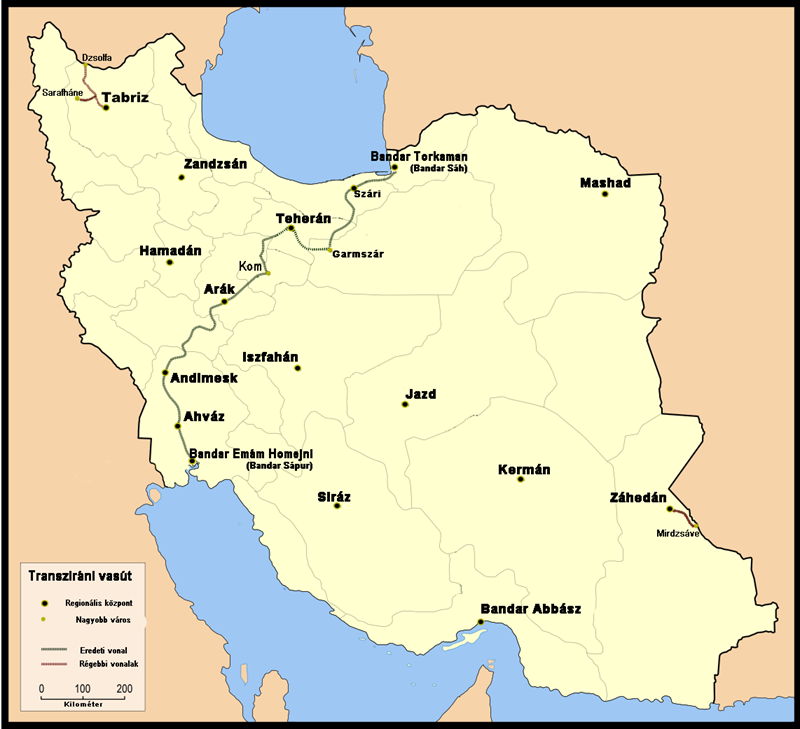
Somewhere north of Tehran, a train slows into a curve carved directly into the mountainside, disappears into a tunnel, and re-emerges a few hundred meters higher on the same slope it just left. The Trans-Iranian Railway is a 1,394-kilometre UNESCO World Heritage railway line connecting the Caspian Sea in the northeast with the Persian Gulf in the southwest, built entirely with Iranian funding between 1927 and 1938. It crosses two mountain ranges, four climatic zones, and terrain that most railway engineers of its era would have called impossible. Nearly a century later, it is still in daily use — a rare thing among the world’s UNESCO sites, and part of what makes it worth understanding properly.
Direct answer: The top experiences on the Trans-Iranian Railway include riding the scenic Tehran–Caspian section through the Alborz mountains, seeing the Veresk Bridge and the Three Golden Lines spiral tunnels, visiting historic stations such as Pol-e Sefid and Veresk, and combining the journey with nearby UNESCO sites including the Hyrcanian Forests and Shushtar Historical Hydraulic System.
Trans-Iranian Railway at a Glance
A Railway That Defied the Mountains
The railway’s route was never going to be simple. It crosses both the Alborz mountains in the north and the Zagros range further south, along with rivers, highlands, forests, and plains, and passes through four distinct climatic zones in the process. Building a functional, economically viable railway across that range of terrain — without exceeding gradients that would make the line impractical to operate — was the central engineering challenge of the entire project.
UNESCO’s own assessment notes that the railway combines spectacular mountain settings with sustained steep mountain grades of less than 3 percent — still considered the maximum practical mountain railway grade today. Railways with steeper gradients have proven problematic to operate, and the Trans-Iranian Railway’s design hits the critical balance point between the outstanding and the impractical.
224 Tunnels and the Search for a Workable Grade
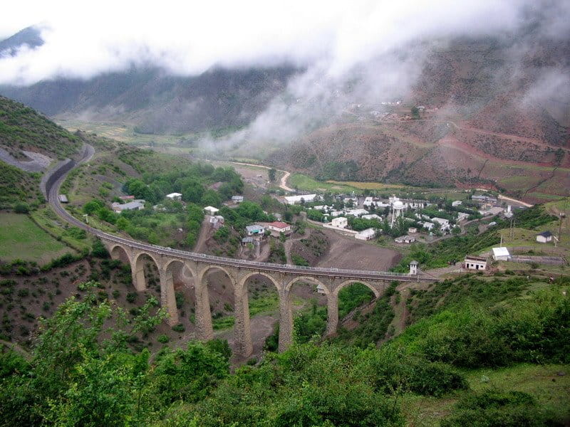
Trans-Iranian railway train winding through the Zagros mountains.
To manage the mountain sections, engineers relied on steep but carefully calculated gradients, generally in the range of 2.2 to 3 percent — close to what is still considered the practical upper limit for a mountain railway before operating costs become unmanageable. Where the terrain simply didn’t allow for a direct route, engineers turned to spiral tunnels, effectively looping the track back over itself inside the mountain to gain elevation more gradually.
In total, the line required 224 tunnels, including 11 spiral tunnels, along with 174 large bridges and 186 smaller ones — a scale of engineering work that UNESCO’s own assessment singles out as exceptional even by the standards of the world’s great mountain railways. The northern segment includes 93 tunnels with a total length of 23.6 kilometers, and the southern segment includes 131 tunnels with a total length of 60.1 kilometers.
📷Photo by Ali Asghari on Wikicommons
The Veresk Bridge: Stone Arch Above the Valley
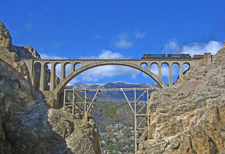
Of all the structures along the route, the Veresk Bridge, in Mazandaran province, is the one most often singled out. Standing around 110 meters above the valley floor with a 66-metre stone arch, it was built without any metal structural framework — an unusual choice even for its time — and required an international team of engineers working with comparatively simple tools.
Local legend holds that, to reassure a public nervous about the bridge’s strength, the engineers and their families stood beneath it as the first train crossed — though this is best treated as popular anecdote rather than confirmed fact. What’s better established is the bridge’s nickname: during the Second World War, it became known as Pol-e Piroozi, “the Bridge of Victory,” for its role in keeping the line — and the supply route it carried — open.
Just a few kilometers south of Veresk Bridge lies the Three Golden Lines (Se Khat Tala) spiral, where the line ascends or descends in a short distance by passing three times through the same area at different heights. Trains descend towards Sari or ascend in the opposite direction by going through the Dowgal twin tunnels — a feat of hillclimbing technique that remains one of the railway’s most photographed sections.
Built at Home: Financing a National Dream
What distinguishes the Trans-Iranian Railway from most large infrastructure projects of its era is how it was financed. Rather than accepting foreign loans — which typically came with strings attached, in the form of political influence or control — the Iranian government funded the entire project through domestic taxes, including levies on tea and sugar.
It’s a detail that says as much about the railway’s meaning as its engineering does: an everyday cup of tea, taxed a little more heavily, quietly became part of building a railway that would reshape the country. UNESCO specifically credits this financing model as central to the railway’s significance, framing it as a deliberate choice to keep the project — and the country’s infrastructure future — under Iranian control.
The project cost around $150 million (approximately 500 million Swiss francs in gold) and was financed mainly by additional excise taxes on imports of tea and sugar. Crucially, Reza Shah insisted that the project be financed entirely through domestic taxes, avoiding foreign loans that had so often led to foreign control in the past.
An International Team, an Iranian Project
Despite being domestically financed, the railway’s construction was genuinely international. The Iranian government worked with 43 construction contractors from a range of countries, and the project is often cited as a model of successful cross-border project management for its time — delivered against extraordinarily difficult terrain, without major foreign investment dictating the terms.
In 1933, Iran concluded a contract with the Danish firm Kampsax, which subcontracted the project in 43 lots to companies from Europe, the USA, and Iran. Kampsax engineers supervised the works on each lot, with coordination from the head office in Tehran. The contract required Kampsax to complete the line by May 1939, but the project was completed under-budget and ahead of schedule, formally opening throughout on 26 August 1938.
📷Photo on Wikicommons
The Railway’s Role in the Second World War
According to UNESCO’s own statement of the railway’s significance, the Trans-Iranian Railway played a genuine role in the Second World War, forming part of what later became known as the Persian Corridor — a route used to move Allied supplies through Iran. In August 1941, Soviet, British, and British Indian forces invaded Iran to protect their oil supply and secure the Persian Corridor supply route from the Persian Gulf to the Central Asian republics of the Soviet Union.
The Allies took over operations of the railway: British and Empire Royal Engineers commanded the Southern Division between Tehran and Bandar Shahpur on the Persian Gulf, while the Soviet Army operated the Northern Division between Tehran and Bandar Shah on the Caspian Sea. When the British first took over the southern part in 1941, the railway was only able to move one freight train per day, hauling a total volume of 978 tons daily in the first quarter of 1942. By September 1943, they were able to move 5,400 tons per day, due to the import of new locomotives, wagons, and more skilled personnel.
In December 1942, the US Army Transportation Corps replaced the British force operating the Southern Division, further increasing freight traffic so that in 1944 it averaged 6,489 tons per day. “Aid to Russia” traffic ceased by May 1945, and shortly afterwards the British restored the line to Iranian State Railways.
UNESCO’s inscription documents even note that some of the era’s important negotiations took place aboard a preserved railway carriage that still exists today. It’s a striking detail, and one that goes some way toward explaining why a railway — rather than a palace or a mosque — was judged to carry the kind of significance UNESCO looks for.
UNESCO World Heritage Criteria, Explained
The Trans-Iranian Railway was inscribed on the Iran’s UNESCO World Heritage List in July 2021, during the 44th session of the World Heritage Committee. It was recognized under two cultural criteria — (ii) and (iv) — for its role as an exceptional feat of mountain railway engineering and as a rare example of a technological and architectural ensemble from the early twentieth century.
Criterion (ii): An Exchange of Human Values
Criterion (ii) recognizes sites that show an important interchange of human values over a period of time, whether in architecture, technology, or design. For the Trans-Iranian Railway, this reflects the exchange of railway engineering knowledge between Iran and the international teams involved in construction, along with the way the finished railway helped revive older trade connections across the region — echoes of routes like the historic Silk Road, now carried by rail instead of caravan.
UNESCO’s statement notes that the railway is the living manifestation of the multi-faceted interchange of human values, represented by the application of railway skills and experience in railway construction, leading to the emergence of a mixed Iranian-Western architectural style. The railway boosted the economy and trade by speeding up transportation, which led to the revival of cultural-historical routes such as the Silk Road and the Spice Route at a specific period in the contemporary history of Central and West Asia during the early 20th century.
Criterion (iv): An Outstanding Technological Ensemble
Criterion (iv) applies to structures or ensembles that illustrate a significant stage in human history. UNESCO’s assessment describes the Trans-Iranian Railway as a fine example of a technological and architectural ensemble representing major stages of long-term development of human, technical, and economic activities as early as the 20th century, in Western Asia.
It played a unique role in the modernization of Iran, first through the function of importing and domesticating western technologies, second through national financing enabling and managing construction activities, and finally through its unique impact on the country’s social, economic, and cultural spheres. The railway has caused a huge increase in trade, and cultural and economic relations between different regions within Iran and between Iran and other countries of the region.
You can read UNESCO’s full official listing and statement of Outstanding Universal Value here: UNESCO World Heritage Centre — Trans-Iranian Railway.
📷Photo by Ninara on Wikicommons
Riding the Trans-Iranian Railway Today
Unlike a museum or a monument, the Trans-Iranian Railway isn’t something you simply visit — it’s something you can still ride, largely on its original route.
Which Section Is Worth Riding
The northern stretch between Tehran and the Caspian coast, through Mazandaran province, is generally considered the most scenic section for travelers, largely because it’s where the railway’s engineering is most visible — the spiral tunnels, the mountain curves, and the Veresk Bridge itself, which can be seen (and felt) from the train as it crosses.
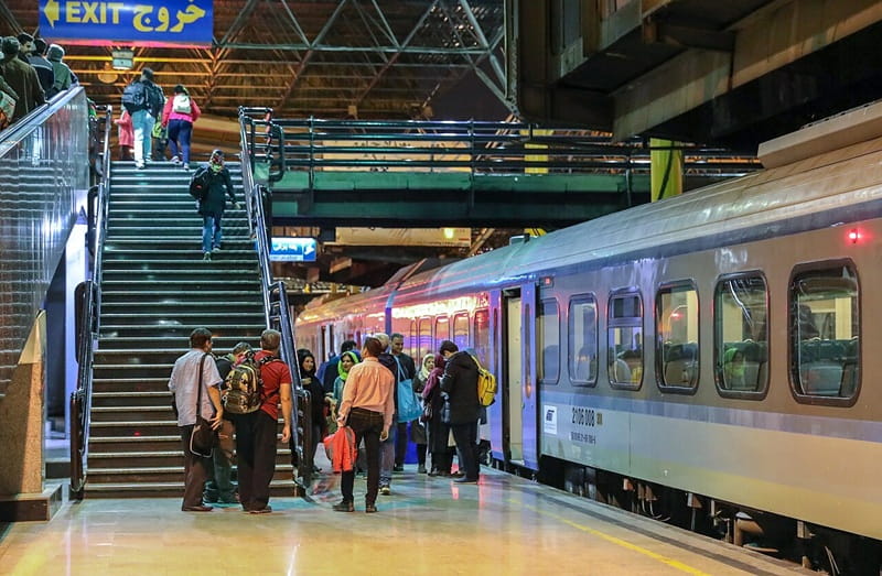
Trains on this route run regularly and include both day and overnight sleeper services connecting Tehran with towns along the Caspian coast, such as Sari and Gorgan. Tickets can be booked in advance through Iran’s national rail booking system, and it’s worth noting that scenery, rather than speed, is the appeal here — this is a slower, more deliberate way to see the transition from Tehran’s high plateau to the forested Caspian lowlands.
What’s Preserved, and What Isn’t
Not every original structure along the line is still in active use. UNESCO’s own documentation notes that some historic stations, workshops, and buildings along the route are no longer in operational use and require ongoing conservation attention — a reminder that “still functioning” doesn’t mean every part of the railway looks exactly as it did in 1938.
The physical fabric of the property is mostly in good condition and its integrity and technical function, and social use has been well maintained. Some sections of the original rail line have been enlarged or slightly modified, but altogether the Trans-Iranian Railway is a living and dynamic industrial and engineering structure that enjoys a good degree of authenticity.
Documenting, monitoring, and conserving the historic buildings and other elements that are no longer in use is needed, and inventories must be completed through thorough documentation of all tangible features that address cultural elements.
Nearby UNESCO Sites Along the Route
The Trans-Iranian Railway’s route puts it in genuine proximity to other parts of Iran’s UNESCO landscape. The Hyrcanian Forests — one of Iran’s natural World Heritage Sites — lie along the railway’s northern stretch near the Caspian coast, and the change in vegetation is noticeable from the train itself as it descends from the Alborz mountains.
Further southwest, the line also passes through the region associated with the Shushtar Historical Hydraulic System, one of Iran’s other UNESCO-listed engineering achievements, separated from the Trans-Iranian line by many centuries but connected by a shared thread of Iranian engineering ambition.
If your route starts in the capital, it’s worth pairing this with time spent among Tehran’s own Qajar-era landmarks before heading north.
Trans-Iranian Railway Practical Travel Tips
When to Go
Spring (April–June) and autumn (September–October) offer the best weather for mountain scenery, with wildflowers in spring and clear skies in autumn. Winter brings snow to the Alborz section — dramatic for photography but potentially disruptive to schedules.
Getting Around
Regular passenger trains run the Tehran–Caspian route, including overnight sleeper services. Book tickets in advance through Iran’s national rail booking system or ask your tour operator to assist. For the best views, sit on the right-hand side heading north (left-hand side returning south).
Booking a Guided Experience
For travelers who prefer a curated journey, Compassimo offers guided tours that incorporate the Trans-Iranian Railway into broader itineraries covering Iran’s UNESCO sites and historic routes. These tours handle logistics, permits, and local guides, allowing you to focus on the experience rather than the details.
Final Thoughts: An Unlikely Monument
Most of Iran’s UNESCO sites are places you stand still in front of — a mosque, a palace, an ancient city. The Trans-Iranian Railway asks something different of you: to move through it, and to notice that a piece of transportation infrastructure can carry the same weight of ambition, ingenuity, and national identity as any monument built to be admired from a distance.
It’s easy to overlook a working railway as heritage, precisely because it doesn’t sit behind a rope or inside a museum case. But the tunnels cut through solid rock, the bridges standing on nearly a century of stone and mortar, and the sheer persistence required to link two coastlines through some of Iran’s most difficult terrain — all of it is still there, and still doing exactly what it was built to do.
For travelers curious about a different side of Iran’s heritage, one measured in kilometres of track rather than centuries of stonework, this is a rare chance to experience a UNESCO site the way it was always meant to be experienced: in motion.
Let this railway be the beginning of your Iranian journey.
FAQs for Trans-Iranian Railway
1. When was the Trans-Iranian Railway built?
Construction began in 1927 and the railway opened fully in 1938, under the direction of Reza Shah Pahlavi.
2. Why is the Trans-Iranian Railway a UNESCO World Heritage Site?
It was inscribed in July 2021 under criteria (ii) and (iv), recognized for its exceptional mountain railway engineering and for representing a significant stage in the development of technology and infrastructure in Western Asia.
3. How long is the Trans-Iranian Railway?
The railway runs approximately 1,394 kilometres, connecting the Caspian Sea in the northeast with the Persian Gulf in the southwest.
4. How many tunnels and bridges does it have?
The line includes 224 tunnels, including 11 spiral tunnels, along with 174 large bridges and 186 smaller bridges.
5. Who paid for the Trans-Iranian Railway?
It was funded entirely through Iranian domestic taxes, including levies on tea and sugar, rather than through foreign loans or investment.
6. Can travelers still ride the Trans-Iranian Railway?
Yes. The railway remains in active daily use, and sections — particularly the route between Tehran and the Caspian coast — are popular with travelers for their scenery and engineering.
7. What is the Veresk Bridge?
The Veresk Bridge is one of the railway’s most notable structures, a roughly 110-meter-high stone arch bridge in Mazandaran province, built without a metal frame and nicknamed “the Bridge of Victory” for its role during the Second World War.
8. Did the Trans-Iranian Railway play a role in World War II?
Yes. According to UNESCO’s own documentation, the railway formed part of the Persian Corridor used to move Allied supplies through Iran during the war.
9. Is the Trans-Iranian Railway connected to other UNESCO sites in Iran?
Its route passes near the Hyrcanian Forests, one of Iran’s natural World Heritage Sites, and runs through the same broader region as the Shushtar Historical Hydraulic System.
10. Is the entire original railway still intact?
Much of it remains in use, though UNESCO’s documentation notes that some historic stations and structures along the route are no longer in active operational use and require ongoing conservation.
11. Where does the Trans-Iranian Railway start and end?
It connects Bandar Torkaman on the Caspian Sea to Bandar-e Emam Khomeini on the Persian Gulf, passing through Tehran, Qom, and Ahvaz along the way
0 Comment